Sunday, August 21, 2011

Iconic Charminar Charms Tourists

On a guided tour we were driven past Charminar, lieu of parking restrictions near the monument.  We had to postpone our visit to the next day.  Luckily the visit to the edifice opens up at 9 am, we had to stand in the queue to buy the entry ticket of  Rs 5 each.  Once we were inside the premise, we had to undergo the security check at the gate, and bags are not allowed while climbing up.  Luckily my wife was wearing a black churidar with the black hand bag, the security allowed us to go through.  We had to climb 50 steps before we reached the first floor, which is equavalent to three floors in normal building.  Beyond this we are not allowed for preserving the safety of the monument i presume.  The next floor is supposed to have provision for Namaz for the Muslims.

History of Charminar :  When an epidemic plague struck the capital of the Sultanate, the king Mohammad Qutub shah prayed to Allah, Please bless the city with peace and prosperity, let millions of men of all caste and creeds, and religions make this their abode, like fish in water.  The foundation for Charminar was laid in 1591 and completed by 1595.

The edifice is built with four minaretes jutting out in four corners. A fable is floated that an underground tunnel exists to escape from Charminar to Golconda, but nobody is aware about its whereabouts.  Each minar 56 metre high with winding staircase to reach the top.  The minars are completed with a dome signifying Islamic architecture.  There are two balconies leading up to the top, which is restricted to public visit.

When lit up in the night the edifice glows as if it has a golden sheen. Halogen lighting fixed at various points  produces such an effect.  The central hall is beautifully embedded with floral designs.  There are inscriptions in Urdu praising the lord i presume.  A mosque is built on the ground floor level, with the central portion barricaded with a fountain like structure.

The archways of the edifice is built in synchronisation leading up to third gateway, in one direction.  The fluted shaped minars has totally 149 steps.  When one ascends the top balcony, he gets to see bustling city of  Hyderabad and Secunderabad, with Hussain Sagar lake, Zoo and Birla mandir, which are all prominent landmarks of the city.

On the left hand side there is Asaf Jung hospital with a domed structure and on the right we have the famous Mecca Masjid.  These two structures are visible from the Charminar balcony.  The Chowmahal Palace of the Nizams is a km away, but covered by buildings and shopping complexes.

The local administration has cleared up lot of space inorder to beautify the surroundings.  At least if they are able to clear one side of the road filled with shops, the monument would look glorious.  But the resistance to shift to alternative locations or take compensation is hindering the progress.  Recently one of the minarets after 420 years was repaired through expert guidance of ASI engineers.  Check out the chaotic traffic in front of  Charminar.

The Iconic Charminar is compared to Taj Mahal in terms of  being a symbol representing the city.  It would augur well if a committee is formed to spruce up the place to bring back the past glory.  The solution lies in clearing at least one km of space on one side and relocating the shops.

   Ack : Photo from Hyderbad tourist site, courtsey wiki.

Saturday, August 20, 2011

Nehru Zoological Park, Hyderabad

One of the finest zoological park was established in 1959, and thrown open to the public in 1963.  It extends to over 380 acres housing Carnivores, Herbivores, Primates, Reptiles, Birds, Nocturnal and Rodents.  The zoo is closed on Mondays.  


Timings of the zoo :  8am to 5 pm


  • Entry Fee               Adult      Rs20         Child      Rs10
  • Train Ride             Adult       Rs15         Child      Rs  5
  • Cycle Ride            Adult        Rs20                       Per hour
  • Vehicle Ride         Adult        Rs100                     Per hour
  • Safari Ride           Adult        Rs 25        Child       Rs10
  • Elephant Ride      Adult        Rs 15         Child      Rs   5
  • Camera still                           Rs 20
  • Video Camera                       Rs100
  • Water bottle deposit             Rs 10
  • Acquarium                             Rs   2
  • Car entry with driver            Rs 500


We were lucky to visit the zoo on a Tuesday without checking out the holiday.  One of the novel feature of the zoo entry is that one has to deposit Rs 10/- towards carrying plastic bottle inside the park.  It is to ensure that you bring back the plastic bottle instead of throwing it in the park and collect back the deposit, which can be followed by other national parks.  The tariffs levied too is reasonable and affordable unlike Banerghatta National park.

Many animals and reptiles are adopted by the patrons and wild life enthusiasts.  The best season to visit the zoo is during winter, which might not be good for photography.  The ideal season is midway during the monsoon season.  The photographs turn out rich and glossy due to the lush green background.  It was raining slightly when we visited.  The photographs and videos will reveal this observation.


We skipped the train ride, safari and boating, to save time since we had to get back for a buffet lunch offered by our hotel.  We avoided the safari since there was 3 bus loads of school children, who would have consumed nearly 2 hours @ 30 minutes each and half an hour lunch break.  Animal sightings on safari is not guaranteed is another reason why we skipped the safari.


Every tourist is recommended to visit Nehru zoological park, it is advisable to visit Charminar and zoological park in one day, since guided tours will not provide you sufficient time to cover these destinations.


Details of  Nehru zoological park Official Website of the Zoo


Golkonda Fortress

Golla Konda in telugu literally means Shepherds hillock, Golkonda hillock was used by farmers in ancient times to graze their sheeps and cows.  This place was selected by Ganpathi Deva in lieu of its elevated platform(  1242 - 1262 ) as an ideal place to erect a mud fortress to station a garrison.  During the two decades reign of the kakatiya king, Ganpathi Deva, Golkonda fort played a strategic part in keeping the enemies at bay.

After the fall of  Kakatiya empire the vijaynagar feudatories took over the Golkonda Fortress in lieu of its strategic importance.  The Fortress was secured with granite structures to station their army.  After the fall of  Vijaynagar Empire in 1565 due to confederation of  Bahamani sultans army, Ibrahim Qutub shah ( 1550 - 1580 ) took over the fortress and beautified it with Islamic architecture.  The wealth plundered from the victory was used to consolidate and expand the Fortress with a palace and gardens.  Thus Golkonda fortress became the capital of the  Golkonda Sultanate.  After ruling for nearly two centuries, the Mughal emperor conquered Golkonda fortress after a prolonged warfare in 1687 and stripped all of its grandeur and opulence.  The wealth of sultanate was surrendered to Aurangazeb( 1658 - 1717 )

Abdul Qutub Shah who was also know as Tana Shah ( 1672 - 1687 ) had to surrender Nur Ul Ain Diamond,  Hope Diamond, Wittelsbach Diamond and Regent Diamond , along with in numerous artefacts made of gold, pearls and sandlewood which catapulted Aurangazeb as the richest monarch in the world.  Further he extracted a huge revenue per annum, which according to estimates amounted to 5 Crores from Golkonda region.  The wealth obtained from these conquests went into building many a edifices in his empire including Bibi ka Maqbara.

Golkonda fortress and city  is spread over an area of  10 sq kms, with the defense occupying most part of it currently and Qutub shah tombs is part of the complex which is located near Golkonda.  Golkonda fortress has been built over a period 3 decades.  The fort by itself is 5 kms in circumference, the outer walls extends to 7 kms.  Golkonda fort remained capital of the sultanate till 1590, later their capital was moved to Hyderabad with the construction of  Charminar, in all probability because the shift was mandated by plague which struck the capital making it risky to survive for the royalty.  A Kali & Haunuman temple was established in the Golkonda premises to ward of the evils of the plague.  The Sultan Mohammad Qutub Shah prayed to Allah for retribution and promised to build an edifice in commemoration.

Golkonda Fortress :  The fortress is secured by 10 km long granite outer wall boundary.  It has 87 bastions some of which are mounted with cannons.  There are 4 draw bridges over the circular moat.  The fort has 8 gateways designed for smooth movement getaway for the royalty and army.  The lowest Enclosure is known as Fateh Dawaja ( victory gateway ) named after Aurangazebs triumph in 1687.  In this enclosure one can experience the acoustic effect of the fort.  A hand clap below the dome can be heard at the highest point 1 km away on the pavilion known as Bala Hisar.  It was meant to signal warning or entry of a guest depending on the intensity of the beat of the drum or bugle.

The main enterance of  the fort is located on the eastern side as per vastu.  The doorways are decorated with Peacock and Lion symbols signifying a blend of  hindu and islamic architecture.  Toli Masjid is situated 2 km away built in 1671 by Mir Musa Khan.  The fort was designed with ingenious water supply system, through wells and channels.

Golkonda fort is well landscaped with a garden, and maintain with plenty of greenary by the ASI.  The Nagina Bagh is the main garden designed by the sultans.  Fort houses the Durbar Hall, wherein public audience and guests to the kingdom were received by the sultans.  A mosque was built in honour of Ibrahim.  The palace is located in the middle of the fort, where the sultans used to reside,

The fort also contains garrison for the generals to reside, along with stables for the horses and elephants. There is an armoury enclosure known as Silah Khana, along with an office.  There is another mosque in the name of  Taramati  along with kali and hanuman temples.  On the immediate left hand side of the enterance ASI office is located in an enclosure which is off limits for the public.

It is ideal to visit the fortress in the evening at around 3 pm to have a complete trip of the fortress and watch the sound and light show which is shown at 7 pm and 8 pm respectively.  During winter the timings are advance by 30 minutes. The sound and light show is narrated in the baritone voice of  Amitabh Bachhan.  There are APSRTC buses commuting to Mehendipatnam, which is bus terminus to the twin cities of Hyderabad and Secundrabad.  It is located just 11 kms from Hyderabad city.

Overall a visit to Golkonda fort is an interesting experience, which calls for stamina to ascend and descend the fortress.  One gets to see the grandeur of the Hindu Islamic architecture and has a peek into the history of  Kakatiyas, Vijaynagar, Sultans and Moghuls.


Friday, August 19, 2011

Bhongir Fortress.Travelogue

We took a risk of planning a trip to telangana territory amidst great uncertainty, whether the agitation will play spoil sport to our clubbing the extended independence holidays was big question mark.  We took a chance and booked our hotel, and one way ticket by inter city express towards warrangal.  Enroute we literally spotted a monolithic rock jutting out with a beautiful fortress wall encircling the egg shaped granite hillock.  We hoped against hope that we will be able to complete our trip to 1000 pillar temple at Hanumkonda and quickly browse through Warrangal fort and return to Bhuvanagiri ( Bhongir ) to ascend this majestic fortress.  We weighed the option, and detrained at Kazipet, and found a bus waiting for us to take us to Hanukonda.  This helped us to save at least precious 2 hours which on the hindsight helped us to cover Bhuvanagiri fortress.

After covering Warrangal fortress we boarded a passenger train heading towards Secunderabad from Warrangal, which was packed to the brim because of the intervening holidays.  We had purchased a ticket for Howrah exp towards Secunderabad, which was delayed by almost 3 hours, which was the ultimate saviour when we had to reach our hotel Spearmint at Hyderabad.  All trains were so jam packed in the evening, that TC advised us to board any train or any compartment.  We realised that it was a great risk we took, it was akin to struggle of a different kind altogether.  But remember the adage that fortune favours the brave, the weather was kind enough, and it rained to cool the temperatures drastically.

We reached the fortress after the closing time at 5.30 ( 10 am to 5 pm ), we requested the counter guy who asked us pay the fee of  Rs 16/- and quickly finish the trip.  The ascent to the fort was quite steep, but the weather was so lovely with breeze and slight drizzle that it made our trek so easy that we reached the height of 609 meters within 40 minutes, which may be a record of sorts.

Luckily the rain gods decided to have a break.  If it had to continue the drizzle the climb into the steep fortress would have been slippery and impossible to trek.  We saw many a tourists returning back to their pavilions since it was fading light.  Enroute i was shooting pictures and taking a short break to catch up the breath.  We had luckily   picked up 2 litre Bisleri water.  It served us well to avoid getting dehyrated and helped us to recoup.

The steel railing helped us to grip and avoid the fear from rolling over sloping granite structure.  The best part of the climb is that the steps are laid with easy inclination. The combination of sheer rock surface ascent and steps made our trek easy.  Midway there is an enclosure which has mantap with a Linga.  It is fortified by walled structure.  Natural water storage points are witnessed was filled with greenary, with water almost dried up.

Once we reached the peak it was almost as if conquered Everest in quick time.  The feeling was smothered by cool breeze blowing over.  Dark clouds were accumulating.  We quickly had a detour of the Palace on top which was built with Islamic architecture.  The palace had literally collapsed and was in a state of absolute ruins.   Below there was a cannon point, signifying that it acted more as strategic battle place.

There is a TV transmission tower of sorts along with a govt building on edge of the hillock, wherein a staff was lowering the Indian flag with great respect.  When we returned to our hotel we realised that Anna was fighting another battle of freedom from corruption.  We heard that he was arrested for declining to call off the protest fast.

HISTORY OF THE BHUVANGIRI FORTRESS :

Earliest known history of the Bhuvanagiri refers to the trade route of the Budhhist in the 10th century.

The credit for this fortress is given to Western Chalukyan king Vikramaditya VI ( 1076 -1126 )  who had ascended the throne after dethroning his elder brother Somesvara II.  Since his reign lasted almost 50 years it was a golden era of the empire.  He patronised arts and literature with Kirtivarma wrote Govaidya ( vet science ) and Bramhashiva wrote Samayaparikshe and earned the title Kavi Chakravathi.  Bilhana a noted poet from Kashmir wrote treatise in the form of Vikramankadevacharita. Vikramaditya VI followed a ritual of donating land daily to the needy.  Thus Vikramaditya earned the title   Tribhuvanamalla ( lord of three world )

He is also associated with building a number of fortress located in and around the capital Basavakalyan.  Bhuvanagiri happens to be one of the prominent ones close to his capital. He built a stone wall which still stands the testimony of times.  The stairways and gateway through arches was built during his reign. He ensured building reservoirs for rain  water harvesting in various strategic point at Bhongir.  He is also associated with building a number of temples in his domain the famous one being Mahadevi temple at Itagi.   After his death the fortress was taken over by the kakatiyas.  Queen Rudrama placed her  guerilla contingent in this fortress to defend her empire.  It is speculated that the Nayaks made this place as their bastion to defend the kakatiya domain.  Eventually they succumbed to intense war by the raiding sultanate army.  The battle was so fiercely fought that enemies suffered a major blow and loss before Nayaks perished.  In honour of their valour a statue is erected at the enterance of fortress of  Narasappa Nayak. The fortress than fell into the hands of  Vijayanagar emperor Krishnadevaraya under Timmarsu.

The Bhongir fortress was repaired and further strengthened by Ibrahim Qutub Shah ( 1550 - 1580 )  after the downfall of the Vijayanagar empire in 1565.  Ibrahim Shah who was once sheltered by the Vijaynagar Emperor became a triator, and joined the confederation of the Bahamani sultanates to vanquish the Vijayanagar emperor Aliya Ramaraya.  He established a mosque and a garrison in this very fortress and stationed a large army as a reserve to protect his kingdom.  A local governor was positioned at Bhongir fortress.  A prison was built to house the criminals and traitors to the kingdom.


A bitter communist rebellion in late 1940 which destroyed the Nizams domain put Bhongir on sleep mode. The genesis of the communist rebellion was undue exploitation of farmers by landlords.  The psychological scar even remains today with greetings from locals " I am your slave "  Bhuvanagiri was one of the hub of protest against exploitation from 1946 to 1951.  The Nizams refused to join the Indian union, and formed an army of supporters called Razzakars to suppress the rebellion.   The Sardar ( Iron Man of  India ) issued the ultimatum to the Nizam, and he had to surrender on 17th Sept 1948. Ultimately the communist rebellion was quelled and state elections were announced.  The good news is that the govt. of  India has sanctioned substantial funds to spruce up this majestic fortress which is spread over 10 square kms.

Thus a visit to Bhongir fortress which is  filled with historical events came to an end, we are longing for more such adventure.


Thursday, August 18, 2011

Rani Rudrama Legacy Warangal Fort

Prologue 

After a disappointing visit to Hanumakonda temple complex, we landed at Warrangal fort on the independence day ( 15/8/2011 ).  We were stunned by the unfolding open air museum of sorts with rain adding lush green background to the monuments.  The grandeur was overwhelming, i was left wondering why should such a complex not be declared a world heritage monument ?  We innocently asked the native gentlemen to explain regarding the historical background of the kakatiya capital.  He was proudly sporting the Indian emblem on his shirt and with pride he went on to explain the background.  His narration was primarily focussed on how such a grand complex was destroyed for its wealth, by the invaders, thus leaving behind the spoils to be excavated by ASI in 2000 AD.  


Time and History has its own way of preserving such exquiste monuments by human and nature’s interference. Warangal Fort is one such classic example.  The invaders literally plundered warrangal fort, where a beautiful incomplete shiva temple existed with ornate pillared arches, emulating the sanchi torana’s.  All the precious gems and jewelleries  adorning the lord and his consorts were taken away and the edifices destroyed.  The complex was filled with sand dunes to cover up their brutality.   Warragal has a history of being invaded 5 times for its wealth. On the hindsight if one were to dwell into survival of non rock cut temples or monuments, the maximum life span is just 500 years, whereas rock cut monuments have longevity beyond imagination.  It does not mean to justify the aggressors act.

Kakatiya History :

·                    Beta I (1000–1030)
·                    Prola I (1030–1075)
·                    Beta II (1075–1110)
·                    Prola II (1110–1158)
·                    Rudradeva I (1158–1195)
·                    Mahadeva (1195–1198) brother Rudradeva
·                    Ganapathi deva (1199–1261)
·                    Rudrama devi (1262–1296)
·                    Prataparudra/ Rudradeva II (1296–1323):    Grandson of Queen Rudramba

Gundaya ( 880 - 950 AD )  is the first historical character associated with Kakatiya dynasty by virtue of his service to Rashtrakuta Emperor Krishna II  (  878 – 914 AD ). In return for his service as gratitude, his son was appointed as governor of  Kurravadi in Warrangal district.  Later Betaraja I ( 1000 – 1030 ) took advantage of the conflict between Chalukyas and Cholas to carve out a small territory and thus establish officially the Kakatiya dynasty.

Betaraja’s son Prola I ( 1030 – 1075 ) was rewarded with Hanamkonda as grant from Western Chalukyan king Someswara I  ( 1942 – 1068 ).  Prola II ( 1110 – 1158 ) took full advantage of the weakening kingdom of the Chalukyas and annexed Mantrakuta.  One of the famous Rulers of  Kakatiya dynasty were Rudradeva I ( 1158 – 1195 ), who expanded and consolidated the empire with conquests of  Godavari Delta, upto Srisailam.  He is credited to have built the thousand pillar temple at Hanamkonda in 1163 AD
Ganapathi Deva ( 1199 – 1261 AD ) ruled for nearly two decades, who was set free by his captors with an understanding that he will support them in case of attack from Hoysalas.  He expanded his territory from Karimnagar, to Ankapalle and in the north upto Ongole. Orugallu became the official capital of  Kakatiya kingdom.  Orugallu literally means a single block of stone.  But he handed over his reign to his daughter Rudrama Devi ( 1262 – 1296 ) in and took a retirement from active running of the administration.  He however contined to guide his daughter. During his reign the foundation for the Golkonda  fort and Warrangal fort too was laid.  Ramappa temple too was constructed during his reign.

Rudrarama's Reign ( 1262 - 1296 ) 

Rudrama Devi (  1262 – 1296 )  Since Ganapathi Deva did not have sons he chose appoint his daughter and trained her to be a warrior.  She was annointed as son according to Putrika ceremony. A male name was designated to her as Rudradeva and declared the queen of Kakatiya kingdom.  History has relegated women rulers to a large extent across the globe. 

Rudrama Devi was almost baptised by fire into the kingdom with invasion from the Jatavarma Sunder Pandya.  Kakatiyas lost their battle in Muttukur ( Nellore ) and the entire kingdom was shaken up.  Nobles and army who resented the queen now started realising that they had no option but to toe the guidelines of their king.  Ganpathi Deva vested the administrative powers in the hands of his daughter.
However in 1266-67 she was devastated with the dual loss of her husband Veerabhadra and her father.  She wanted to commit suicide but was refrained by the noblity to continue her reign, she was promised all co-operation.  She became a de-facto ruler of Kakatiya under difficult circumstances. 

According to legendary folk tale Rani Rudrama was not very much fond of  music or literature, but was inspired by Shiva Tandav. It was known as Perini.  She took up dancing as a form of exercise and introduced it as part of training the royal guards.  Due to her marriage to the Chalukyan prince Veerabhadra, she had the advantage of seeking the co-operation of  their artisan to finish incomplete edifice to spruce up her capital.
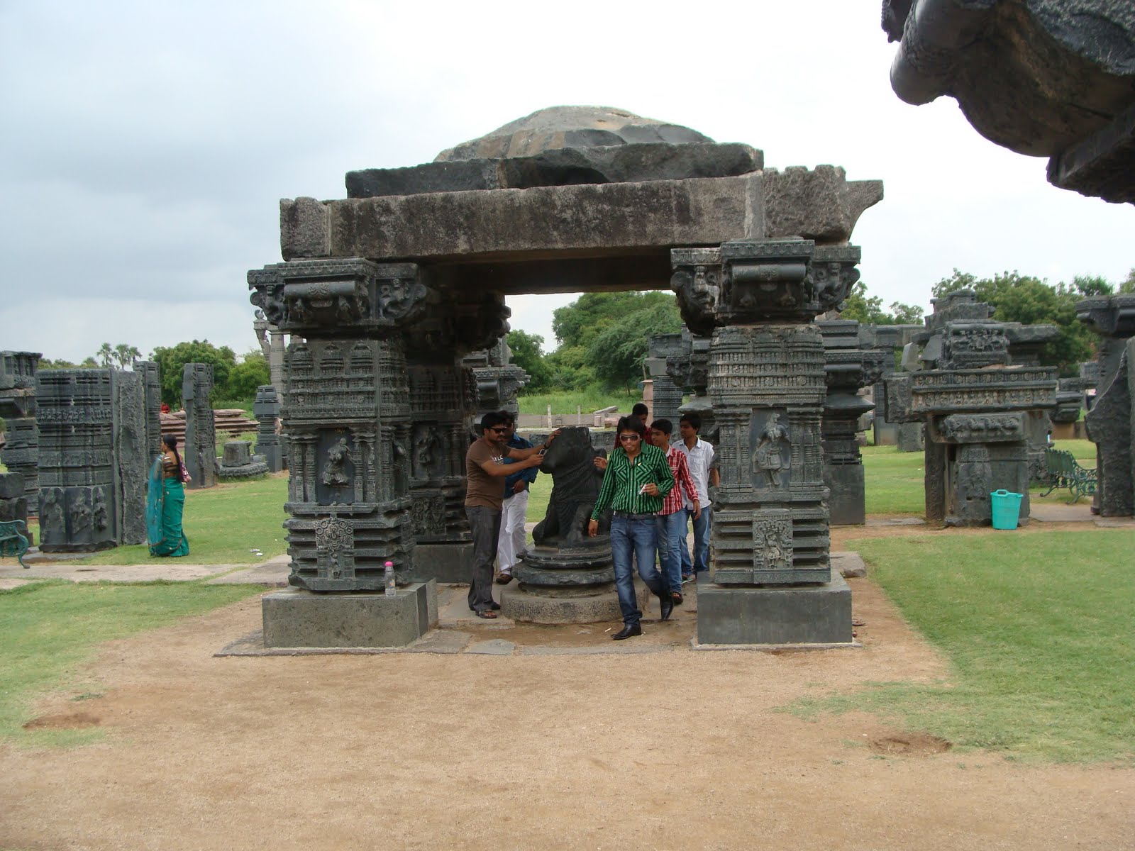
Warrangal Fort


Warrangal fort is credited to have been completed during her reign. The fortress was reinforced with a circular moat which was filled with crocodile to deter the enemies.  She ensured that her dance form got embeded into the pillars and façade of the temples.  The Peacock symbol was given prominence in the arches.  It obviously symbolised the beauty and pride of the empire The arches are also known as Toranas, which is laid out during festive season. There are 4 arches one facing each geographical direction. These toranas can be compared to the Sanchi arches, but overshadows them in grandeur and execution.  She ensured construction of  Bhadrakali temple in Hanamkonda.  Another prominent fortress  was consolidated at Bhuvangiri ( Bhongir ).

The architecture of the temple and arches utilised soapstone, pink granite and black granite.  It obviously was sourced from different parts of her kingdom and neighouring zones.  The wealth derieved from mining precious stones seems to have fuelled the growth of kakatiya empire. The famous Kohinoor diamonds seems to have been unearthed at Kollur on the banks of river Krishna during her reign, which was bartered away for peace by her grandson Prataprudradeva II, when he was under dire straits and verge of defeat in 1310 by Malik Kafur. 

The sculptures on the panel and facades of the warrangal fort complex reveals that Rani Rudrama devi excelled in all types of traditional warfare including sword fight, shooting arrows, horse riding, hunting of wild animals, etc  She is depicted on the elephant too in one of the reliefs in the temple complex.
In her endeavour to leave a trace of her legacy, she ensured that the capital was a perfect blend nature and architecture.  The hillock Ekshila temple was built in honour of  Lord Shiva.  The locale of this temple is surrounded by a lake with a pundits head jutting out of water.  The pundit is almost in meditation with his eyes closed.

Venkateswara, Shambuni Gudi, Jangamiah and Ramalaya are other temple edifices located in the complex.  The queen worshipped Lord Shiva, Bhadrakali, Ekaveera and Padmakshi.  The main Shivalaya temple inside the complex was unfortunately unfinished because of her untimely death in the battlefield in 1296.
Rani Rudrama devi is known to have been benevolent in sharing the wealth with soldiers at times of being victorious in battles against Mahadeva Raja from Devgiri ( Daulatabad ) This strategy ensured loyalty of the army in her quest to retain the kakatiya suzereignty in the region.  She chose Prataprudradeva II ( 1296-1323 ) ( grandson )  as her successor as per the advice of her father Ganpathideva. 

Rani Rudrama can be considered as one of the most valiant and distinguished queen in the league of  Rani Chennama of Kittur ( East India Company ) , Durgavathi of Godwana ( Akbar ) Rani Chennamabairavdevi ( Sulva Keladi ) Razia Sultan ( Delhi Sultanate ) and the legendary Rani Laxmi Bai ( Jhansi ).  She will be remembered forever in the annals of history for conceiving a world class edifice for her capital city Warangal. Her reign was one of the golden age of  Telugu speaking kingdom.  


Ack : Wikipedia, Blogs, CultureIndia, and Research papers.


Sid s Blog

Marco Polo Travels


Friday, August 12, 2011

Kalil a buddhist legacy ?


The clear evidence of the conversion of a Jain Heritage into Bhagwati temple is found at Kallil. The statues of the theerthankaras must have been destroyed by the vandalisers and in it s place a Hindu goddess statue has been installed. The proof of the conversion can be seen on the unfinished image of Buddha or Jain theertankara which belongs to 800 AD as per carbon dating. The location chose by the Bhikshuks was ideal for meditating, which was practiced far away from the dense human settlement. If we go by the terrain, it must have been close to some river or water source. The monks used to walk up to the water source for their daily chores of bathing and fresh up.

According to me the Buddhist figure on the rockface must have belonged to the Ashokan period, when the emperor relinquished violence to spread Dhamma. In view of large scale vandalism of the remains, one cannot conclusively prove whether this place belong to jain or buddhist heritage.

The 100 odd steps leading up to the temple seems to be laid of late, after it was declared a protected monument in 1965. Previously the steps must have been laid on the rock bed circumbulating around the rocky phase and leading upto to the temple. There is new laid out pathway currently with skid proof tiles laid out of cemented tiles. The entire area is now being converted to ensure flow of vehicles and parking slot is being designed to attract piligrims.

Behind the Bhagvathi temple we find the meditating area which is well laid out with ancient steps. The serenity of the atmosphere is quite captivating. There are some ancient statues preserved belonging to the converted segment of Bhagvathi. Animal sacrifices must have been taking place in terms of chicken etc to please the goddess, which seems to have been stopped. There is one cave like crevice which may have housed ancient mankind too, if one has time one can keep exploring the surroundings, but we were running behind schedule.

The priests family have naturally occupied the surrounding areas and thriving. We had to take permission to photograph the Buddha image on the rock face, which they reluctantly gave us, since it was the evidence of conversion.

Crude form of conversion of Jain places of worship will be dealt with elsewhere, which will reveal an indirect method adopted to take over the premises. I am wondering why the Hindus followed this coercive method, particularly when Jainism and Buddhism could almost be considered to part of Hinduism. Is it the brahmanical hatred against the dalits which compelled them to undertake such coercive methods or is it the easy way out to transform the Buddhist or Jainism place into Hindu place of worship. This phenomenon is most found in Kerala region, where even today the conservative practice of removing the shirt before entering the temple premise is followed. Rest of the areas have discarded this practice. Some temples I did not enter as a mark of protest, even though being a hindu, I preferred to prostrate outside the temple premises, maybe it would keep the priests happy.


LOCATION : Enroute to Munnar from Keladi to Kallil can be covered from Ernakulam or Angamally in kerala. It is approximately 4 kms detour from Oddakali which is 15 km away from Perambavoor. There is one more route via Kottapadi and one can exit towards Oddakali and join the main route to Munnar. The approach road to the temple is incomplete, which one has to trek almost a km to reach the destination.

Monday, August 8, 2011

Beaches of S Kanara


Live your life so that your epitaph could read, No Regrets at all!

A trip to the virgin beaches of konkan coast can act as rejuvenating experience far away from the maddening crowd. No wonder my Bill and his family make it a habit to visit Mangalore and its non-polluted beaches once in 2 years at least from Paris.

Last time around when I visited Panambur and Ullal beaches I was not impressed at all. Ullal beach had a rustic look with lot of litters spoiling the looks. Panambur beach was smelling of Gasoline while you dip into the waves.

We decided to look further at Suratkal and Kaup beach, surprisingly it was refreshing. The water was clean and devoid of any petroleum smell. I hope the oil companies do not pollute the waters with their waste being dumped into the sea.

Both the beaches have a wonderful atmosphere, with lighthouse acting as guiding forces for navigation of ships. In Suratkal beach one finds golden sand, with rocks littered around the shores. At Kaup beach the lighthouse is situated on huge rocky terrain attached to the beach.

The visitors to Suratkal beach are primarily KREC students, and a few local residents. One can climb the lighthouse at Suratkal beach by paying an enterance fee of Rs 5 per head. It is lovely sight of the coastline and one gets to see the refinery at a distance, along with the harbour. The visit to the light house is allowed between 3.30 to 5.30 pm only. On clear weather days, one can view lovely sun setting in the west from Suratkal beach.

Kaup beach is preferred by the tour operators, because it has proper road access for maneuvering the vehicles, whereas Suratkal beach is inconvenient. Kaup beach has a bar and restaurant, for those who would like to have a swig. The rural atomosphere of Kaup beach is alluring. The intensity of the waves depends on the prevailing tide cycle. One has to definitely exercise caution exploring the waves, during the high tides.


Kaup beach lighthouse view is breathtaking. The entry is allowed on payment of a fee, and videography is charged exhorbitantly. The surrounding coconut tree groves along with the coastal topography is a great photographic locale. Many a kannada films have been shot in this location such as Subha Mangala, etc. The lighthouse is located on top of a rocky formation, almost similar to vivekanada rockmemorial. There seemed to have been a adjustant hillock fort during ancient times, which is destroyed.

Location : Suratkal beach is located 16 kms away from Mangalore City. One has to take deviation on the left as one reaches the KREC college ( which is now NITE ) and drive a km towards the beach on the tar road. There is not much parking area.

Other Beaches in South Kanara :  Someswar, Ullal, Panambur, Sashitulu, Hejmadi, Malpe, Marvanthe, beaches to name a few.  If one wants to cover all the beaches in the region it might take 3 days along with a trip to Virgin Isle.


Friday, August 5, 2011

Underground trekking, Belum Caves


Belum cave is located in the dry and arid zone of Ananthpur district, lot of cuddapah stones are mined in the nearby area, with a huge cement plant too located in the vicinity.

These caves were inhabited in the ancient times by Buddhists and Jain monks, many of the relics discovered during the restoration process is housed in the museum located at Ananthpur town. It may have been dwelling of cavemen dating back to 4500 B.C., the potteries and beads discovered by ASI points to this fact.

Logistics : The Belum cave is approximately 272 kms from Blore via NH 7 with a deviation from Ananthpur town via Tadpatri town. There is no proper accommodation in Belum cave except for dormitory facility. The ideal place to book one’s accommodation is either at Ananthpur town or at Tadipatri town. The next alternative if one is traveling from Hyderabad 320 is take up accommodation at Kurnool or alternatively at Yaganti.

Belum cave is considered to be longest caves on the plains with 3229 meters and 120 feet depth, and second longest cave in India. Some of the longest caves are located in Meghalaya, Mizoram and Manipur belt. Majority of them are still raw and unexplored to a large extent due to thick forest cover.

Discovery and Mapping of Belum caves was officially undertaken by Robert Bruce Foote in 1884 AD. It remained under total neglect with the mining lobby dumping ground for all the waste in and around the area. A German team headed by Herbert Daniel Gabauer in 1982 and 1983 conducted a detailed mapping of the cave along with local reddies Chalpatti, Ramswami, Padmanabiah and Chinnaih.

APTDC : The Andhra govt. finally decided to step in and develop Belum caves as a tourist destinations in 1999. With a massive budget of 7.5 crores work began in the right earnest to ensure cleaning, lighting, ventilating, blowers, railings etc were installed at all strategic points. Belum caves were thrown open to public in 2003. There is a canteen for tourist, bathroom facility near the entry point. The guides who are available with torch to guide the tourist into the caves. We were lucky to get a free guide deployed, one of course has to tip them for their efficiency in guiding quickly and ensure that we emerge out of the cave safely. There are helmets available which is generally not used by the tourists.


A huge Buddha statue has been installed close to the hillock near the enterance to signify the original inhabitants of the Belum caves. On the hillock BELUM is engraved like Hollywood insignia.

Sections of Belum Cave :

Dhyan Mandir or Meditation centre : It is located near the enterance. A huge hall almost looks like a bedroom with a pillow on the horizon. Most of the Buddhist monks and sages resided in this portion and meditated. All the artifacts found in this portion have been relocated to the museum.

1000 Hoods : The stalactite formation on the wall looks like a cobra hoods, just imagine number of cobras opening their hood to strike, a scary scenario, but it is just a figment of imagination of the locals to describe the scenario being displayed.

Banyan Tree Hall : This section resembles a huge banyan tree spreading its roots and branches all over.

Mandapam : This huge stalactite hall looks like a marriage hall. Who knows marriages may take place in future……….for a movie Lol.

Musical chamber : The stalactite pillar formation give out musical notes when stuck with a wooden cane or once knuckles.

Patalganga : A perennial stream of water flows into the Belum village located 2 km away from this spot.


Overall a visit to Belum cave can be quite a thrilling experience, it is generally opened between 9 am to 5 pm. One has to be prepared for visiting the cave with plenty of water, and take due care while passing through some narrow passage. In certain areas one is bound to feel clausterphobic, but not very scary since the lighting is quite sufficient. There are ventilators and blowers at strategic points, it is better to take a breather under them and proceed further. Since the best of the caves are located in the explored spots, Belum cave is the best experience one can have underground. The sheer adventure and aura to experience an underground exploration is fulfilled at Belum.

avinash

avinash
cannons ready to fire

About Me

My photo
Bangalore, Karnataka, India
Basically i am down to earth, take friendship to its logical end. It is my endeavour to create a wealth of co-operative ventures. Basically being a marketing man i have the acumen to spot winners. I am privileged to travel the length and breadth of the country, courtsey my father, who was with Indianoil, my employers such as Nutrine, Kurl-on, Hindustan Pencils, Prestige, Crystal, Bell Ceramics, Pentel, Sezal, Commander. Currently i am involved in Tourism, Booking Air Tickets, Agent for Jungle Lodges and Resorts Limited and Taj Group of Hotels and a numerous hotels across India. Depending on the needs of a traveller i would recommend the destination and accommodation best suited to their budget. Humour takes me on. Let us have a win win situation for all. I love travelling for sake of adventure, photography and discovering the heritage. Life is a journey and let us enjoy our drive. Come share your travel experience on indiabackpacker.